Our search for water
Below please find the presentations that were given at the Casino Maltese on the 22nd April 2015.
Speakers and videos:
| 01 - Judge Giovanni Bonello | The historical perspective of the Wignacourt aqueduct. (video) |
| 02 - Dr. Keith Buhagiar | The springs feeding the Wignacourt aqueduct system. (video & presentation) |
| 03 - Mr. Manuel Sapiano | The Wignacourt aqueduct. A hydrological perspective (video & presentation) |
| 04 - Mr. Brian Restall | A historical GIS narrative of the Wignacourt aqueducts and their spring sources during the British period. (video & presentation) |
| 05 - Discussion | (video) |
This effort is part of a wider study that attempts to apply historical GIS to spring and environmental management in the Maltese Islands. The goal of this project is to assess data collection methods/sources, to compile available information, and inform land managers, conservation organizations through geocollaborative tools.
It is also our intention to raise awareness about our fragile ecosystems, and establish deeper connections to nature and our restricted spaces.
All material provided via NHM is strictly for non-commercial and educational use.
Below please find further details on our presentation titled:
"A historical GIS narrative of the Wignacourt aqueducts and their spring sources during the British period."
Click on the image below to read the presentation , and click here for the video recording.
 |
PLEASE RESPECT 3RD PARTY PROPERTY IF VISITING ANY OF THE SITES.
Visiting galleries may be physically, mentally and emotionally challenging. Any person reading this material is responsible for getting the proper instruction in the techniques and equipment necessary for caving and assumes all responsibility for injuries incurred to yourself or those injuries you inflict on others. No claim is made about the suitability of this information for any purpose, either stated or implied. By reading this information, you accept full responsibility for it's use, and any consequences of that use.
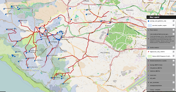
Click on the image below to visit our online GIS platform using QGIS.
 |
Credit is due to numerous entities that allowed us to make use of material held in their collections, namely the:
Sustainable Energy and Water Conservation Unit, Works and Infrastructure Department, National Library of Malta, Government of Malta, Heritage Malta, National Archives of Malta, University of Malta, Malta Environment and Planning Authority, Water Services Corporation, Catch the Drop and various other local organisations.
Special mention is due to the numerous authors who have given water in our historical landscape direct attention, and unwittingly contributed to this spatial perspective. Special mention goes to Dr. K. Buhagiar, Fr. Eugene Theuma, Dr. F. Menchetti, Mr. Edward Said and Dr. S. C. Spiteri for their seminal work.
All costs for this effort have been absorbed by Projects in Motion Ltd. as part of its social responsibility efforts for 2015.
Regards,
Brian Restall (Projects in Motion Ltd.)
![]()